
The Garmin Marine Network is a proprietary ethernet-based network that seamlessly connects several plug-and-play marine components, delivering position data, charting, weather, sonar, radar and other important data to boaters' fingertips. The entire system is waterproof and completely plug-and-play. Anchors of the new system are the powerful GPSMAP® 3210 and GPSMAP 3206C chartplotters, plus the basic, lower-priced GPSMAP 3205C. These multifunction displays (MFDs) automatically detect any and all peripherals once they're connected. Boaters can connect a GPS antenna and one remote sensor directly to the MFD, or, with the addition of the GMS™ 10 Network Port Expander, users can connect multiple MFDs and sensors to the same network. Each networked MFD can be configured independently.
 |
GPSMAP
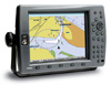
3210 For boaters wanting a large-format display along with the benefits of a seamless plug-and-play system and built-in maps for U.S. coastal areas, including Alaska and Hawaii, this is your plotter. The GPSMAP 3210's huge 10.4-inch diagonal display delivers vivid color and detail — even in direct sunlight. |
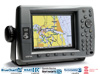 |
GPSMAP 3206 This plotter has all the features of the 3210, just on a slightly smaller scale. The 6.4-inch MFD with sunlight-readable color shows incredible contrast and detailing, even in direct sunlight. It can serve as a standalone plotter or network with other MFDs and sensors to deliver XM weather, radar and sonar. |
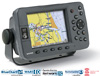 |
GPSMAP 3205 Offers a mid-range option for boaters wanting the benefits of a seamless plug-and-play system and built-in maps for U.S. coastal areas, including Alaska and Hawaii. It has a 5-inch color display, and it can serve as a standalone plotter or network with other MFDs and sensors to deliver XM weather, radar and sonar. |
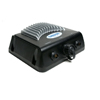 |
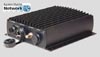
GSD 22 A powerful remote sounder that plugs directly into the Garmin Marine Network for use with our network chartplotters — or into the new Garmin CANet™ for use with the 292/392/492 series chartplotters. |
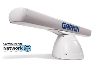 |
GMR 404 & 406
4-foot and 6-foot open array radar antennas allow you to scan more of what's out there while you're on the water with outstanding clarity, precision and target definition. |
 |
GDL 30/30A Real-time graphical weather data coverage of the United States (except Alaska and Hawaii) are put literally at a boater’s fingertips with the GDL 30/30A. The GDL 30/30A black box weather data receiver provides real-time information directly on the GPSMAP 3010C or GPSMAP 3006C. This receiver is completely waterproof and relays a continuous transmission of 20 different types of graphical weather information that can be overlaid on a chartplotter. |

Image shows multiple MFDs and sensors connected to the Garmin Marine Network.
Seamless Integration: By networking various sensors with the 3000 series plotters, boaters can have complete awareness of what's happening around them.
Easy-to-use: MFDs automatically detect any and all sensors once connected and the data displays on all plotter screens.
Expandable: boaters can connect a GPS antenna and one network sensor directly to the MFD, or, with the addition of the GMS 10, users can connect multiple MFDs and sensors to the same network.